


R500 RTK Mapping Drone
R500 RTK Mapping Drone
Technical parameters
- Weigh motor wheelbase: 460mm
- Body size: 367mm*367mm*228mm
- Motor: KV 650rpm/V
- Electric adjustment: continuous current 45A
- Propeller size: Diameter * pitch: 11*4.5 inch
- Normal takeoff weight: 1.38kg(including battery and head)
- Maximum takeoff weight: 2.0kg
- Rise Speed:factory default 5.0m/s, (adjustable from 3 to 8m/s)
- Falling Speed: factory default 3.0m/s, (adjustable from 3 to 8m/s)
- Horizontal Flight Speed: GPS mode: 5m/s
- Motion mode: factory default 10m/s (adjustable from 5 to 20m/s)
- Attitude mode: 15m/s (no wind environment)
- Maximum tilt Angle :GPS mode: 25°
- Motion mode: 30° Posture mode: 30°
- Maximum rotational angular velocity: 150°/s
- Maximum flight altitude: 4,500 m
- Maximum wind speed: 17 m/s
- Maximum endurance: about 60 minutes (without 6K camera)
- About 50 minutes (with 6K camera)
- Operating temperature: -10℃ to +40℃
- Positioning accuracy: GPS: vertical ± 1.5m, Level ±0.4 m (GPS positioning works normally)
- Coordinate with network RTK: horizontal 1cm+1ppm, vertical 2cm+1ppm (GPS positioning works normally, network RTK connection is normal)
- Voltage: 22.2 V
- Capacity: 7000 mAh
- Battery type: LiPo 6S
- Energy: 155.4 Wh
- Charging ambient temperature: 5℃ to 40℃
- Model: JXRC - H12
- Operating frequency: 2400MHz to 2483MHz
- Maximum communication distance: 12KM (open withoutshelter, no electromagnetic interference)
- Display equipment: 5.5-inch 1920*1080 1000NITS highlight screen
- Charging interface: Type-c
- Battery: 3.7V 10000mAh LiPo 1S
- Endurance time :8~24 hours
- Operating temperature: -10℃ to 40℃
- Charging ambient temperature: 5℃ to 40℃
- Weight: 600g
- Size: 190 * 152 * 94 mm
R500 RTK Mapping Drone
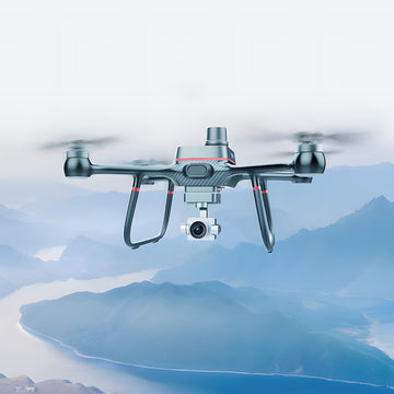
R500 RTK centimeter-level drone, the body is designed with lightweight carbon fiber body, lightweight, to the hand ready to take off. Flight endurance Up to 60 minutes, 7 level super wind resistance level. With three-axis stabilized small gimbal quick detachable design, support 6K UHD camera, starlight night vision camera, infrared thermal imaging camera hanging camera, infrared thermal imaging camera mounted.
-

Integrated Carbon Fiber fuselage
R500 RTK UAV, the fuselage of lightweight carbon fiber fuselage design, light weight for frame, ready to fly. 60 minutes flight time with Grade 7 wind resistance.Equipped with three-axis small
-

Network RTK
Integrated new RTK module, with strong anti-magnetic interference capability and accurate positioning capability, providing real-time centimeter-level positioning data
-

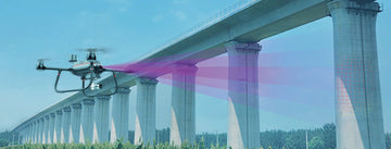
12KM Max Transmission
R500 RTK UAV adopts 2.4G long-distance transmission system, which can transmit the maximum map distance up to 12KM. Strong anti-interference ability, stable and reliable transmission

Born for aerial survey
positioning system and high-performance imaging system, it is portable and easy to use to comprehensively improve the efficiency of aerial survey.


Checking the scene


